'; ?>
Hiking and Nature Trail Accessibility in the Great Smoky Mountains National Park
The Great Smoky Mountains national park is known as one of the best places to hike in the United States as it has more than 1,000 miles of designated hiking trails, manways, abandoned and active roadways.
Most of the hiking trails in the Great Smoky Mountains National Park have ruts, jutting rocks and other obstacles that may also require water crossings either on footbridges or by wading and rock hopping.
People with mobility issues may find that many of the hiking trails in the Great Smoky Mountains national park can be too difficult as they are rugged and can be quite steep and a challenge for any hiker.
Sometimes hiking trails may require that you climb over newly fallen trees, or may navigate potions barely wider than the width of a footstep with steep edges, no railings or guide lines. People with impaired vision may have significant issues on hiking trails without the assistance of a guide or service animal.
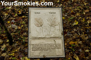 Tactile display for visually impaired in Sugarlands
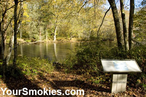 Oconaluftee N Carolina River Trail is accessible.
The park service only recognizes the Sugarlands Valley Trail as accessible however I would highly recommend 4 trails in the Great Smoky Mountains national park as assessable for persons with mobility issues using a wheelchair or visually impaired persons can traverse on their own or with minimal help.
There are also 2 paved trails in the Great Smoky Mountains national park both of which are very steep. For persons who are confined to a wheelchair to use either one of these trails (the Laurel Falls Hiking Trail and the Clingmans Dome Hiking Trail), they must be highly functional in their mobility and even then may still require considerable assistance - especially on the Clingmans Dome Hiking Trail.
Dogs are confined to only 2 hiking trails in the park, the Gatlinburg Hiking Trail and the Oconaluftee River Trail, but working service animals (dogs or horses) are allowed and all of trails.
Recommended Accessible Trail:
Gatlinburg Hiking Trail in the Great Smoky Mountains National Park
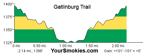
Gatlinburg Hiking Trail: Great Smoky Mountains National Park
Hiking Tail Name: Gatlinburg Hiking Trail
Hiking Trail Status:
Trailhead Location: Sugarlands Visitor Center, Gatlinburg Tennessee
Trail Length: 2.14 miles round trip
Trailhead Elevation: 1,398 feet
Elevation Gain: 101 feet
Elevation Drop: 101 feet
Trail Type: Gravel path, paved areas and wooden bridge
Trail Use: Walking, dogs allowed
Trail Condition: Excellent
Latitude: 35°68'50.60"N
Longitude: 83°53'70.53"W
Recommended Accessible Trail:
Oconaluftee River Hiking Trail in the Great Smoky Mountains National Park
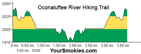
Oconaluftee River Trail: Great Smoky Mountains National Park
Hiking Tail Name: Oconaluftee River Trail
Hiking Trail Status:
Trailhead Location: Oconaluftee Visitor Center, Cherokee North Carolina
Trail Length: 3.60 miles round trip
Trailhead Elevation: 2,038 feet
Elevation Gain: 140 feet
Elevation Drop: 240 feet
Trail Type: Gravel path, paved areas
Trail Use: Walking, dogs allowed
Trail Condition: Excellent
Latitude: 35°51'20.14"N
Longitude: 83°30'34.52"W
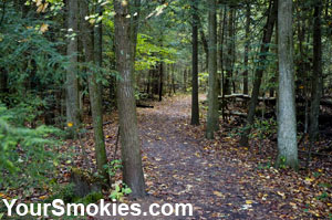 Gatlinburg Trail: wooded homesteads and river
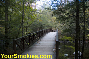 A Beautiful bridge on the Gatlinburg Hiking Trail
Recommended Accessible Trail:
Foothills Parkway in Wears Valley, Maintained by Great Smoky Mountains Natl Pk
Hiking Tail Name: Foothills Parkway Wears Valley
Hiking Trail Status: Closed for construction until further notice.
Trailhead Location: Wears Valley Road (321)(73), Between Townsend and Pigeon Forge Tennessee
Trail Length: 10 miles round trip
Trailhead Elevation: 1,439 feet
Elevation Gain: feet
Elevation Drop: feet
Trail Type: Abandoned Paved Road
Trail Use: Walking, Bicycle, Horse, Dogs allowed
Trail Condition: Excellent
Latitude: 35°43'18.45"N
Longitude: 83°38'44.37"W
Recommended Accessible Trail:
Sugarlands Valley Trail in the Great Smoky Mountains National Park
Hiking Tail Name: Sugarlands Valley Trail
Hiking Trail Status: Open
Trailhead Location: Newfound Gap Road (441) less than 1/2 mile South of Sugarlands Visitors Center, Gatlinburg TN
Trail Length: 0.5 mile round trip
Trailhead Elevation: 1,537 feet
Elevation Gain: Negligible
Elevation Drop: Negligible
Elevation Grade: Less than 5%
Trail Type: Paved in Cement
Trail Use: Walking
Trail Condition: Excellent
Latitude: 35°40'46.38"N
Longitude: 83°31'52.84"W
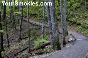 Laurel Creek Falls Trail: with beautiful scenery
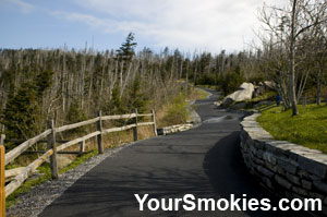 Clingman's Dome Trail is paved but very steep.
Accessible Trail:
Laurel Creek Falls Trail in the Great Smoky Mountains National Park
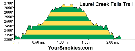
Laurel Creek Falls Trail: Great Smoky Mountains National Park
Hiking Tail Name: Laurel Creek Falls Trail
Hiking Trail Status:
Trailhead Location: Little River Road (73) Between Sugarlands Visitor Center and Elkmont Area in TN
Trail Length: 2.17 miles round trip
Trailhead Elevation: 2,311 feet
Elevation Gain: 751 feet
Elevation Drop: 751 feet
Trail Type: Paved in Asphalt
Trail Use: Walking
Trail Condition: Passable with surface damage, cracks and ruts, quite steep with significant drop offs.
Trail Warning: Persons using this trail with a wheelchair must be highly functional in their mobility and may still require considerable assistance.
Latitude: 35°67'18.67"N
Longitude: 83°58'06.42"W
Accessible Trail:
Clingman's Dome Hiking Trail in the Great Smoky Mountains National Park
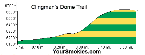
Clingman's Dome Trail: Great Smoky Mountains National Park
Hiking Tail Name: Clingman's Dome Trail
Hiking Trail Status:
Trailhead Location: Clingman's Dome Parking Area, Off Newfound Gap Road near NC TN Border
Trail Length: 1.20 miles round trip
Trailhead Elevation: 6,619 feet
Elevation Gain: 504 feet
Elevation Drop: 504 feet
Trail Type: Paved in Asphalt
Trail Use: Walking
Trail Condition: Excellent but extremely steep.
Trail Warning: Persons using this trail with a wheelchair must be highly functional in their mobility and may still require considerable assistance.
Latitude: 35°55'70.17"N
Longitude: 83°49'60.22"W